RIM2D
Highly Efficient 2D Hydraulic Simulation of Fluvial, Pluvial and Urban Flooding. RIM2D is a raster based inundation model solving the inertial formulation of the shallow water equation, including the consideration of drainage. It is implemented in CUDA Fortran and leverages parallelisation on GPUs.
82
mentions
3
contributors
Description
Rapid Inundation Model 2D RIM2D – Highly Efficient 2D Hydraulic Simulation of Fluvial, Pluvial, Coastal and Combined Flooding
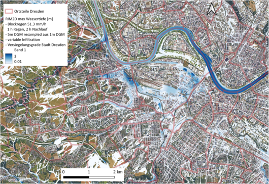
The core of the RIM2D software consists of a 2D flood model that calculates surface inundation dynamics in a raster-based approach using simplified shallow water equations. In urban areas, simulations can be carried out at high spatial resolutions of ≤ 5 metres, accounting for buildings and roads. Urban drainage via the sewer network and infiltration are incorporated through a capacitive approach applied to sealed and unsealed surfaces, respectively.
RIM2D produces spatially explicit flood maps as output, along with the loading on the wastewater system at high temporal resolution, aggregated across the entire municipality. From the simulations, inundation depths and flow velocities can be extracted, from which further flood impact indicators can be derived — such as risk to human life, vehicle displacement, and expected structural damage to buildings.
Core Features:
- Flood simulation for fluvial, pluvial, coastal and combined flooding, at both large and small scales and in urban environments → a complete solution for municipalities and cities
- Ability to use freely available geodata directly in raster format for simulations → straightforward model setup and transferability, including worldwide application
- Short computation times through massive parallelisation on Graphics Processing Units (GPUs) → enables use in operational forecasting (e.g. precipitation forecast → hydrological model → RIM2D or precipitation forecast → RIM2D), as well as probabilistic risk analyses with a high number of model runs
- The straight foreward model structure enables extensive automation of model setup for fast and resource-efficient creation of application models and transferability to other areas/municipalities
Thanks to these features, RIM2D holds decisive advantages — particularly over the coupled 1D-2D models currently used as standard for simulating urban flooding. With those models, neither operational forecasting nor probabilistic analysis is feasible due to long model runtimes. Furthermore, even larger municipalities can be simulated in their entirety — rather than just partial areas — which is likewise generally not possible with the coupled approaches of existing models, owing to their high data and computational demands.
User groups
In addition to the scientific community, user groups for the software include engineering firms, local authorities, government agencies, and insurance companies.
Dual licensing:
The software and an associated QGIS plugin are available free of charge for scientific purposes under an EUPLv1.2 license. Access to the repository is available upon request.
For commercial purposes, there is a proprietary version of the software and various product lines (RIM2D Cloud, RIM2D Engine, RIMahead). Further information is available on our website: www.rim2d.eu

Participating organisations
Reference papers
- 1.Author(s): Shahin Khosh Bin Ghomash, Patricio Yeste, Heiko Apel, Viet Dung NguyenPublished in Natural Hazards and Earth System Sciences by Copernicus GmbH in 2025, page: 975-99010.5194/nhess-25-975-2025
- 2.Author(s): Shahin Khosh Bin Ghomash, Heiko Apel, Kai Schröter, Max SteinhausenPublished in Natural Hazards and Earth System Sciences by Copernicus GmbH in 2025, page: 1737-174910.5194/nhess-25-1737-2025
- 3.Author(s): Heiko Apel, Jakob Benisch, Björn Helm, Sergiy Vorogushyn, Bruno MerzPublished in Frontiers in Water by Frontiers Media SA in 202410.3389/frwa.2024.1310182
- 4.Author(s): Heiko Apel, Sergiy Vorogushyn, Bruno MerzPublished in Natural Hazards and Earth System Sciences by Copernicus GmbH in 2022, page: 3005-301410.5194/nhess-22-3005-2022
Mentions
- 1.Author(s): Alessa Trüdinger, Jörn Birkmann, Mark Fleischhauer, Stefan GreivingPublished in Sustainable Development Goals (SDG) – Umsetzung in Praxis, Lehre und Entscheidungsprozessen, Die Flutkatastrophe 2021 by Springer Fachmedien Wiesbaden in 2026, page: 245-26210.1007/978-3-658-48688-4_16
- 2.Author(s): Bruno Merz, Heiko Apel, Xiaoxiang Guan, Björn Guse, Li Han, Dung Viet Nguyen, Sergiy VorogushynPublished in Sustainable Development Goals (SDG) – Umsetzung in Praxis, Lehre und Entscheidungsprozessen, Die Flutkatastrophe 2021 by Springer Fachmedien Wiesbaden in 2026, page: 41-5710.1007/978-3-658-48688-4_4
- 3.Author(s): Gwyneth Matthews, Calum Baugh, Christopher Barnard, Corentin Carton De Wiart, Juan Colonese, Stefania Grimaldi, Daniel Ham, Eleanor Hansford, Shaun Harrigan, Stine Heiselberg, Helen Hooker, Sazzad Hossain, Cinzia Mazzetti, Leonardo Milano, Francesca Moschini, Karen O’Regan, Florian Pappenberger, Daniel Pfister, Ragindra Man Rajbhandari, Peter Salamon, Arthur Ramos, Kay Shelton, Elisabeth Stephens, Dimitar Tasev, Monica Turner, Marc van den Homberg, Julia Wittig, Ervin Zsótér, Christel PrudhommePublished in Flood Forecasting by Elsevier in 2025, page: 299-35010.1016/b978-0-443-14009-9.00014-6
- 4.Author(s): Lemuel Clark Velasco, Alyssa Jenn Estose, Melcris Opon, Emily TabanaoPublished in Lecture Notes in Networks and Systems, Advances in Information and Communication by Springer Nature Switzerland in 2024, page: 449-46610.1007/978-3-031-53960-2_29
- 1.Author(s): Rodrigo Bezerra, Julian Eleutério, Pedro Solha, Bruno Brentan, Carlos de Mello, Manuel Herrera, André RodriguesPublished in Journal of Hydroinformatics by IWA Publishing in 2026, page: 495-51710.2166/hydro.2026.180
- 2.Author(s): Shahin Khosh Bin Ghomash, Siqi Deng, Heiko ApelPublished in Natural Hazards and Earth System Sciences by Copernicus GmbH in 2026, page: 85-10110.5194/nhess-26-85-2026
- 3.Author(s): Yen-Cheng Lin, Cheng-Wei Wu, Hao-Che HoPublished in 202610.1016/j.jhydrol.2026.136015
- 4.Author(s): Juliette Godet, Eric Gaume, Pierre Javelle, Thomas Dias, Pierre Nicolle, Olivier PayrastrePublished in International Journal of Disaster Risk Reduction by Elsevier BV in 2026, page: 10605810.1016/j.ijdrr.2026.106058
- 5.Author(s): Hannes Leistert, Andreas Hänsler, Max Schmit, Andreas Steinbrich, Markus WeilerPublished in Geoscientific Model Development by Copernicus GmbH in 2026, page: 2023-203710.5194/gmd-19-2023-2026
- 6.Author(s): Pierfranco Costabile, Margherita Lombardo, Carmelina Costanzo, Ioannis Tsoukalas, Vasilis BellosPublished in International Journal of Disaster Risk Reduction by Elsevier BV in 2026, page: 10599810.1016/j.ijdrr.2026.105998
- 7.Author(s): Zoë E. Bovermann, Jörg Dietrich, Ann-Kathrin KoesslerPublished in International Journal of Disaster Risk Science by Springer Science and Business Media LLC in 2026, page: 240-25210.1007/s13753-026-00712-2
- 8.Author(s): Tim Busker, Daniela Rodriguez Castro, Sergiy Vorogushyn, Jaap Kwadijk, Davide Zoccatelli, Rafaella G. L. Oliveira, Heather J. Murdock, Laurent Pfister, Benjamin Dewals, Kymo Slager, Annegret H. Thieken, Jan Verkade, Patrick Willems, Jeroen C. J. H. AertsPublished in Natural Hazards and Earth System Sciences by Copernicus GmbH in 2026, page: 1457-147810.5194/nhess-26-1457-2026
- 9.Author(s): Alisson Caetano da Silva, JAIME Joaquim da Silva Pereira Cabral, SILVANETE Severino da Silva, ANDERSON Luiz Ribeiro de Paiva, SIMONE ROSA DA SILVAPublished in 202610.26848/rbgf.v19.02.p1157-1180
- 10.Author(s): Margherita Lombardo, Giulia Evangelista, Pierluigi Claps, Pierfranco CostabilePublished in 202610.1016/j.ijdrr.2026.106284
- 11.Author(s): C. Dessers, P. Archambeau, S. Erpicum, B. Dewals, M. PirottonPublished in Journal of Hydrology by Elsevier BV in 2026, page: 13490110.1016/j.jhydrol.2025.134901
- 12.Author(s): Marcos Julien Alexopoulos, Panayiotis Dimitriadis, Emela Mitsi, Demetris Koutsoyiannis, Denis Istrati, Theano IliopoulouPublished in Frontiers in Built Environment by Frontiers Media SA in 202610.3389/fbuil.2026.1757749
- 13.Author(s): Damir BekićPublished in Water by MDPI AG in 2026, page: 101110.3390/w18091011
- 14.Author(s): Xiaoxiang Guan, Bruno Merz, Viet Dung Nguyen, Li Han, Heiko Apel, Shahin Khosh Bin Ghomash, Ravikumar Guntu, Heidi Kreibich, Sergiy VorogushynPublished in 202610.1029/2025ef007048
- 15.Author(s): Qiuxu Yan, Jingcheng Yuan, Dong Wu, Yunfei Lin, Zheng LianPublished in Sustainability by MDPI AG in 2025, page: 5010.3390/su18010050
- 16.Author(s): Nils Christian Hoenow, Kiran Karki, Maximilian Nicolaus BurgerPublished in Climatic Change by Springer Science and Business Media LLC in 202510.1007/s10584-025-04070-8
- 17.Author(s): T. Lazzarin, P. Costabile, D.P. VieroPublished in Journal of Hydrology by Elsevier BV in 2025, page: 13361710.1016/j.jhydrol.2025.133617
- 18.Author(s): Jian Su, Jonas Wied Pedersen, Ida Margrethe Ringgaard, Morten Andreas Dahl LarsenPublished in npj Natural Hazards by Springer Science and Business Media LLC in 202510.1038/s44304-025-00077-4
- 19.Author(s): André Felipe Rocha Silva, Julian Cardoso Eleutério, Heiko Apel, Heidi KreibichPublished in Natural Hazards and Earth System Sciences by Copernicus GmbH in 2025, page: 1501-152010.5194/nhess-25-1501-2025
- 20.Author(s): Belinda Rhein, Heidi KreibichPublished in Natural Hazards and Earth System Sciences by Copernicus GmbH in 2025, page: 581-58910.5194/nhess-25-581-2025
- 21.Author(s): Robert Chlumsky, James R. Craig, Bryan A. TolsonPublished in Geoscientific Model Development by Copernicus GmbH in 2025, page: 3387-340310.5194/gmd-18-3387-2025
- 22.Author(s): Markus Mosimann, Olivia Martius, Andreas Paul ZischgPublished in Weather and Climate Extremes by Elsevier BV in 2025, page: 10081710.1016/j.wace.2025.100817
- 23.Author(s): Franziska Tügel, Katrin M. Nissen, Lennart Steffen, Yangwei Zhang, Uwe Ulbrich, Reinhard HinkelmannPublished in Natural Hazards and Earth System Sciences by Copernicus GmbH in 2025, page: 4673-469210.5194/nhess-25-4673-2025
- 24.Author(s): Anna Heidenreich, Heather J. Murdock, Annegret H. ThiekenPublished in Journal of Flood Risk Management by Wiley in 202510.1111/jfr3.70021
- 25.Author(s): Jan Handwerker, Christian Barthlott, Matteo Bauckholt, Alexandre Belleflamme, Alexander Böhmländer, Erik Borg, Galina Dick, Peter Dietrich, Bernd Fichtelmann, Gernot Geppert, Klaus Goergen, Andreas Güntner, Suad Hammoudeh, Maxime Hervo, Elias Hühn, Milin Kaniyodical Sebastian, Jan Keller, Martin Kohler, Peter Knippertz, Michael Kunz, Solveig Landmark, Yanxia Li, Mehrdad Mohannazadeh, Ottmar Möhler, Mona Morsy, Husain Najafi, Nithila Devi Nallasamy, Annika Oertel, Oldrich Rakovec, Hendrik Reich, Marvin Reich, Harald Saathoff, Luis Samaniego, Martin Schrön, Claudia Schütze, Thorsten Steinert, Franziska Vogel, Sergiy Vorogushyn, Ute Weber, Andreas Wieser, Hengheng ZhangPublished in 202510.3389/feart.2025.1555755
- 26.Author(s): Sergiy Vorogushyn, Li Han, Heiko Apel, Viet Dung Nguyen, Björn Guse, Xiaoxiang Guan, Oldrich Rakovec, Husain Najafi, Luis Samaniego, Bruno MerzPublished in Natural Hazards and Earth System Sciences by Copernicus GmbH in 2025, page: 2007-202910.5194/nhess-25-2007-2025
- 27.Author(s): Xiaoxiang Guan, Viet Dung Nguyen, Paul Voit, Bruno Merz, Maik Heistermann, Sergiy VorogushynPublished in Natural Hazards and Earth System Sciences by Copernicus GmbH in 2025, page: 3075-308610.5194/nhess-25-3075-2025
- 28.Author(s): Poulomi Ganguli, N. Nithila Devi, Heiko Apel, Sergiy Vorogushyn, Prachi Pratyasha Jena, Chandranath Chatterjee, Bruno MerzPublished in Geophysical Research Letters by American Geophysical Union (AGU) in 202510.1029/2025gl115795
- 29.Author(s): Juliette Godet, Pierre Nicolle, Nabil Hocini, Eric Gaume, Philippe Davy, Frederic Pons, Pierre Javelle, Pierre-André Garambois, Dimitri Lague, Olivier PayrastrePublished in Earth System Science Data by Copernicus GmbH in 2025, page: 2963-298310.5194/essd-17-2963-2025
- 30.Author(s): Orfeas Karountzos, Marcos Julien Alexopoulos, Theano Iliopoulou, Christina Iliopoulou, Denis IstratiPublished in E3S Web of Conferences by EDP Sciences in 2025, page: 0300310.1051/e3sconf/202565103003
- 31.Author(s): Alessa Truedinger, Joern BirkmannPublished in Journal of Flood Risk Management by Wiley in 202510.1111/jfr3.70033
- 32.Author(s): N. Nithila Devi, Soumendra Nath KuiryPublished in Water Resources Research by American Geophysical Union (AGU) in 202410.1029/2023wr035334
- 33.Author(s): Ruining Ma, Jida Liu, Shi AnPublished in International Journal of Disaster Risk Reduction by Elsevier BV in 2024, page: 10468310.1016/j.ijdrr.2024.104683
- 34.Author(s): Markus Mosimann, Martina Kauzlaric, Simon Schick, Olivia Martius, Andreas Paul ZischgPublished in Environmental Modelling & Software by Elsevier BV in 2024, page: 10593610.1016/j.envsoft.2023.105936
- 35.Author(s): Husain Najafi, Pallav Kumar Shrestha, Oldrich Rakovec, Heiko Apel, Sergiy Vorogushyn, Rohini Kumar, Stephan Thober, Bruno Merz, Luis SamaniegoPublished in Nature Communications by Springer Science and Business Media LLC in 202410.1038/s41467-024-48065-y
- 36.Author(s): Alexander Fekete, Beate RheinPublished in Geosciences by MDPI AG in 2024, page: 4610.3390/geosciences14020046
- 37.Author(s): Lisa Burghardt, Elena-Maria Klopries, Holger SchüttrumpfPublished in Wasser und Abfall by Springer Science and Business Media LLC in 2024, page: 12-1510.1007/s35152-024-1847-x
- 38.Author(s): Joy Ommer, Jessica Neumann, Milan Kalas, Sophie Blackburn, Hannah L. ClokePublished in Natural Hazards and Earth System Sciences by Copernicus GmbH in 2024, page: 2633-264610.5194/nhess-24-2633-2024
- 39.Author(s): Veruska Muccione, Marjolijn Haasnoot, Peter Alexander, Birgit Bednar‐Friedl, Robbert Biesbroek, Elena Georgopoulou, Gonéri Le Cozannet, Daniela N. SchmidtPublished in WIREs Climate Change by Wiley in 202410.1002/wcc.883
- 40.Author(s): Alberto Montanari, Bruno Merz, Günter BlöschlPublished in Hydrology and Earth System Sciences by Copernicus GmbH in 2024, page: 2603-261510.5194/hess-28-2603-2024
- 41.Author(s): Sarah Lindenlaub, Katharina S. Matthes, Annegret H. ThiekenPublished in International Journal of Disaster Risk Reduction by Elsevier BV in 2024, page: 10468510.1016/j.ijdrr.2024.104685
- 42.Author(s): Joy Ommer, Sophie Blackburn, Milan Kalas, Jess Neumann, Hannah L. ClokePublished in Progress in Disaster Science by Elsevier BV in 2024, page: 10031510.1016/j.pdisas.2024.100315
- 43.Author(s): Davide Wüthrich, Paul A. Korswagen, Harish Selvam, Jan Oetjen, Jeremy Bricker, Holger SchüttrumpfPublished in Journal of Flood Risk Management by Wiley in 202410.1111/jfr3.13024
- 44.Author(s): Boris Gailleton, Philippe Steer, Philippe Davy, Wolfgang Schwanghart, Thomas BernardPublished in Earth Surface Dynamics by Copernicus GmbH in 2024, page: 1295-131310.5194/esurf-12-1295-2024
- 45.Author(s): Kun Wang, Jian Chen, Hao Hu, Yuchao Tang, Jian Huang, Youbing Wu, Jingyu Lu, Jinjun ZhouPublished in Water by MDPI AG in 2024, page: 338310.3390/w16233383
- 46.Author(s): Arnau Bayón, Daniel Valero, Mário J. FrancaPublished in Journal of Flood Risk Management by Wiley in 202410.1111/jfr3.13002
- 47.Author(s): Shahin Khosh Bin Ghomash, Heiko Apel, Daniel Caviedes-VoullièmePublished in Natural Hazards and Earth System Sciences by Copernicus GmbH in 2024, page: 2857-287410.5194/nhess-24-2857-2024
- 48.Author(s): Mathilde de Goër de Herve, Wieke D. PotPublished in Environmental Sciences Europe by Springer Science and Business Media LLC in 202410.1186/s12302-024-00928-3
- 49.Author(s): Thomas Roggenkamp, Jürgen Herget, Thomas RoggenkampPublished in Global and Planetary Change by Elsevier BV in 2024, page: 10454110.1016/j.gloplacha.2024.104541
- 50.Author(s): Seth Bryant, Guy Schumann, Heiko Apel, Heidi Kreibich, Bruno MerzPublished in Hydrology and Earth System Sciences by Copernicus GmbH in 2024, page: 575-58810.5194/hess-28-575-2024
- 1.Author(s): RK Pontman, J.C.J.H. Aerts, Paolo Avner, Jens de Bruijn, Rafaella Gouveia Loureiro Oliveira, Bramka Arga Jafino, Hans de Moel, Moussa Sidibe, Tim Sebastiaan BuskerPublished in 202610.2139/ssrn.6966611
- 2.Author(s): Mingze Sun, Natthachet Tangdamrongsub, Yu Sun, Jianzhi Dong, Edwin H. Sutanudjaja, Mikhail SmilovicPublished by Elsevier BV in 202510.2139/ssrn.5362740
- 3.Author(s): Markus Mosimann, Olivia Martius, Andreas Paul ZischgPublished by Elsevier BV in 202410.2139/ssrn.4893831
- 4.Published by Copernicus GmbH in 202410.5194/egusphere-2023-2420-rc2
- 5.Author(s): Alberto MontanariPublished by Copernicus GmbH in 202410.5194/egusphere-2023-2420-ac1
- 6.Author(s): Alberto MontanariPublished by Copernicus GmbH in 202410.5194/egusphere-2023-2420-ac2
- 7.Published by Copernicus GmbH in 202410.5194/nhess-2024-183-rc2
- 8.Author(s): Mohammed Albared, Hans-Peter Beise, Manfred StüberPublished by Springer Science and Business Media LLC in 202410.21203/rs.3.rs-4689483/v1
- 9.Author(s): Joy OmmerPublished by Copernicus GmbH in 202410.5194/egusphere-2024-296-ac2
- 10.Author(s): Seth Bryant, Guy Schumann, Heiko Apel, Heidi Kreibich, Bruno MerzPublished by Copernicus GmbH in 202310.5194/hess-2023-156-supplement
- 11.Published by Copernicus GmbH in 202310.5194/egusphere-2023-2420-rc1
- 12.Author(s): Alberto Montanari, Bruno Merz, Günter BlöschlPublished by Copernicus GmbH in 202310.5194/egusphere-2023-2420
- 13.Author(s): Joy Ommer, Sophie Blackburn, Milan Kalas, Jess Neumann, Hannah L. ClokePublished by Elsevier BV in 202310.2139/ssrn.4626476
Contributors
Contact person
HA
Heiko Apel
Designer, Developer and Maintainer
GFZ German Research Centre for Geoscience
0000-0002-8852-652X
Mail HeikoHA
Heiko Apel
SV
Sergiy Vorogushyn
GFZ German Research Centre for Geosciences
JH
Julian Haas
GFZ Helmholtz Centre for Geosciences
Helmholtz Program-oriented Funding IV
Research Field
Research Program
PoF Topic
Subtopic