All software
gfzrnx
The unique GFZ software gfzrnx plays a central role for the processing of RINEX files from GNSS observations. The toolbox for file check and manipulation supports RINEX observation, navigation and meteorological data.
- BEIDOU
- Earth & Environment
- Galileo
- + 6

GIPPtools
A collection of software utilities that aid with initial pre-processing of recorded (seismic) data supporting users that borrow instruments from the GIPP.
- Cube
- Earth & Environment
- geophysics
- + 4
- Java
- TeX
- Shell
- + 2

Habitat Sampler
Habitat Sampler (HaSa, Community Version), an innovative tool that autonomously generates representative reference samples for predictive modelling of surface class probabilities.
- autonomous sampling
- Earth & Environment
- image classification
- + 1
- HTML
- R
- Shell

MapMan
MapMan visualises data from gene expression analyses. Genes or proteins with a common function are visualised and evaluated together. Mercator assigns the annotations for this. Changes in processes and pathways can be revealed, visualised and evaluated quantitatively.
- Annotation
- Earth & Environment
- Gene Expression
- + 2
MassBank
MassBank is an open source mass spectral library for the identification of small chemical molecules of metabolomics, exposomics and environmental relevance.
- database
- Earth & Environment
- mass spectrometry
mobile Drilling Information System (mDIS)
mDIS is a database management application for capturing and curating meta data on geological samples, drilling progress, and related datasets such as images or geophysical well logs. It is easily adaptable and ensures that all data is compiled and quality controlled in one place.
- data management
- drilling
- Earth & Environment
- + 1
- PHP
- Vue
- JavaScript
- + 2
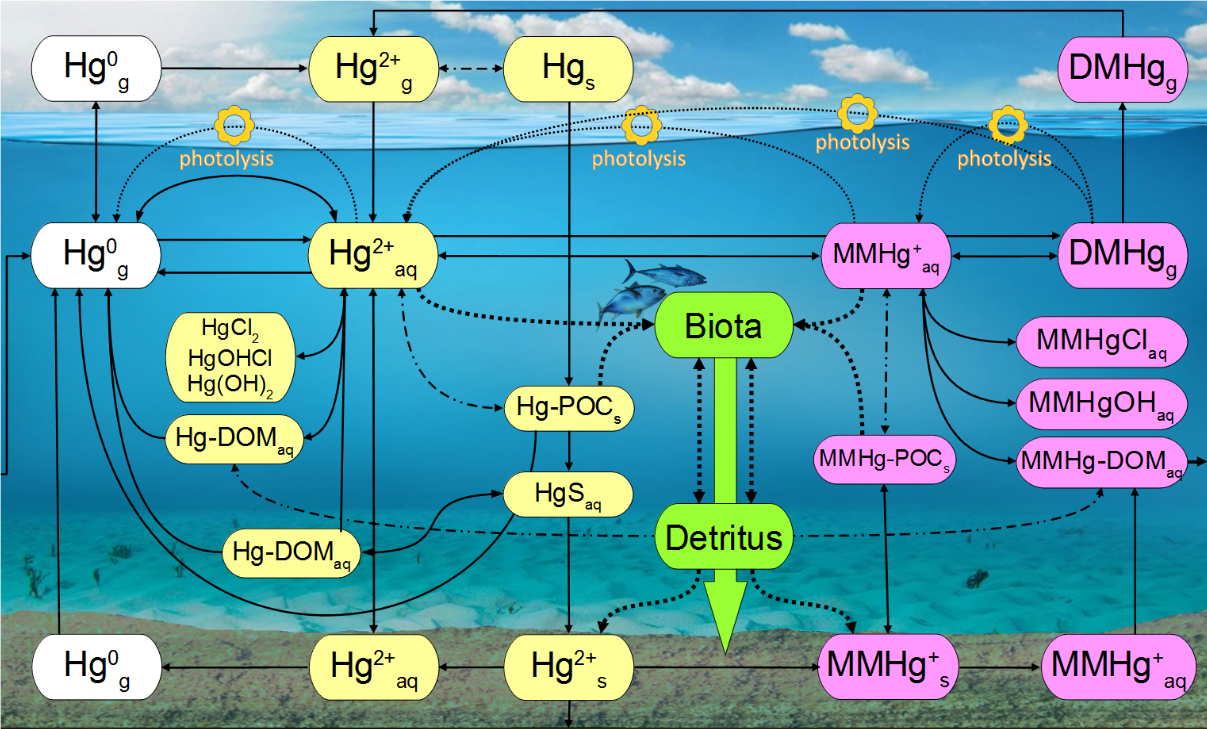
MERCY
The marine mercury cycling model MERCY v2.0 is a chemistry transport and bio-accumulation model for mercury (Hg). It implements all known processes for marine (pelagic and benthic) Hg cycling into a biogeochemical 3D ocean-ecosystem model. https://gmd.copernicus.org/preprints/gmd-2021-427/
- Bioaccumulation
- Chemistry Transport Modeling
- Earth & Environment
- + 6
mHM
The mesoscale Hydrologic Model (mHM) is a well established hydrological model used by the scientific community. It is under active development with dozens of contributors and has an open community always interested in discussions.
- Earth & Environment
- mesoscale hydrologic model
- mHM
- + 2
- AGS Script
- Fortran Free Form
- Python
- + 2

ODM2SMS
A tool to migrate sensor metadata from the observation data model to the Helmholtz Sensor Management System via API.
- Earth & Environment
- metadata
- Research Data Management
- + 1
- Python
- Dockerfile
OSADCP Toolbox
Open-source Python toolbox called OSADCP for scientists to convert, clean, calibrate and organize binary raw vessel-mounted Acoustic Doppler Current Profiler (ADCP) data for scientific use. The toolbox is designed to process ADCP measurements in deep water by Teledyne RDI Ocean Surveyor ADCPs.
- Data Visualization
- Earth & Environment
- FAIR Data
- + 5
- Python

otter
The otter Framework combines community network analysis using Co-Occurrence networks, Louvain Clustering and Convergent Cross Mapping networks. Funding through the Helmholtz DataHub Initiative; project iLOVE.
- Community Dynamics
- Earth & Environment
- python
- Python
PeakPerformance
PeakPerformance is a Python toolbox for estimating peak areas from mass-spectrometry or HPLC datasets under uncertainty. It applies Bayesian inference using the PyMC library to parametric models of peak curves.
- Data analysis
- Earth & Environment
- mass spectrometry
- + 4
- Python
- TeX